


Moldova renewable auction raises questions over ownership transparency
4 hours ago
The Mediterranean has spent the summer soaking up heat. That heat will comes back as rain this autumn. A lot of rain.
With the hottest summer on record, the Mediterranean has absorbed record and sea temperatures are literally off the scale – climatologists have been forced to redraw the axes of their charts to accommodate the never-seen-before results.
Heat turns into humidity. When the temperatures begin to fall in the coming months, the humidity turns into rain. Record hot seas in the summer mean record rainfall, flooding and storms in the autumn.
Sea surface temperatures across virtually the whole Mediterranean basin are far above normal, with parts of it running between 28°C and 33°C, according to measurements circulated by meteorologist JJ Gonzalez Aleman of Spain's state weather agency.
“The Mediterranean is burning,” he wrote. “And it is not a metaphor.”
The EU’s meteorological satellite service Copernicus put the anomaly across parts of the sea at as much as 6°C above the long-term average in the first half of this year, and around 82% of the world's oceans went through marine heatwave conditions over the same period.
None of that energy has gone anywhere. It sits in the water in the air until the first autumn cold intrusions arrive to squeeze it out as precipitation. Southern Europe has been on the receiving end of that exchange in successive Septembers and Octobers of what is now an annual disaster season.
On land the summer has read as drought. Record wildfires have swept France, Spain and more recently the Balkans. France reached 43°C in the fifth major heatwave of the year, with hundreds of cities under alert. Hungary has been running its energy system around a Danube at record lows, and nuclear plants there and in Romania have been forced to shut down as river temperatures rose to the point where they can’t cool the reactors.
The heatwaves have set Europe up for flash floods and worse. Baked ground is the worst possible surface for a month of heavy autumnal rain. Water runs off hardened soil instead of sinking into it, gathers in the rivers and turns a downpour into a flash flood.
However, in the short-term some relief is expected that might take the edge off a looming disaster. Most of Europe is due significant rainfall over the coming week, with 50-100 mm possible in the areas most in deficit, according to the forecaster Ventusky. That is welcome for rivers and crops, and softening ground that has been close to zero moisture for months will take some of the edge off what follows.
Russia's Far East is already showing the wet end of the same year. Severe flooding has turned the Amur around Khabarovsk into what residents are calling an inland sea, while southern Europe is still grappling with wildfires.
Seven per cent per degree
Warmer air holds more water – the rule of thumb is 7% more per 1’C of warming, under the Clausius-Clapeyron relation. The atmosphere already carries roughly 10% more water vapour than it did 30 years ago.
Extreme rainfall rises faster than the vapour itself, closer to 15% for each 1°C, because the heaviest downpours pull moisture in from a wide area rather than wringing out only what sits overhead. World Weather Attribution's read is that current warming levels alone would be expected to lift rainfall intensity by around 10%.
Heat also holds the rain back. A warmer atmosphere hangs on to moisture for longer, which stretches the gaps between rainfall and loads more water into each event when it finally breaks.
Death by deluge
The Mediterranean has already shown how deadly the summer's stored heat can be. On September 10 and 11, 2023, Storm Daniel came ashore in eastern Libya after crossing a sea left unusually warm by climate change, and dropped a day of extraordinary rain on the hills above Derna.
Two dams above the city, Abu Mansour and Wadi Derna, gave way in the night and sent a wall of water several metres high through a sleeping town. Neither had been maintained since 2011, despite maintenance contracts worth millions of dollars that were never completed. Subsidence and cracks had been found in them as far back as the early 1990s.
The Libyan Red Crescent put the dead at as high as 11,300 in Derna alone. World Weather Attribution's own count days later was 3,958 confirmed dead in the city, a further 170 elsewhere in Libya, and more than 10,000 people still missing. Divers searched the sea because bodies were being washed back onto the beaches.
“Storm Daniel is yet another lethal reminder of the catastrophic impact that a changing climate can have on our world,” said the UN High Commissioner for Human Rights, Volker Turk.
The attribution study put the rainfall at a one-in-300 to one-in-600 year event and found that something as extreme as Libya's had been made up to 50 times more likely and up to 50% more intense by a climate 1.2C warmer than the pre-industrial one. In Libya, it noted, the magnitude sat far outside anything previously recorded.
The same low-pressure system had already crossed the northern Mediterranean. Between September 4 and 7 it flooded Greece and Bulgaria, killing 17 and four respectively; seven died in Turkey and six in Spain. Greek agriculture was written off for five years or more.
Rebuilding Derna was later costed at $1.8bn. Twelve officials were jailed over the dam collapses in 2024.
A year's rain in a day
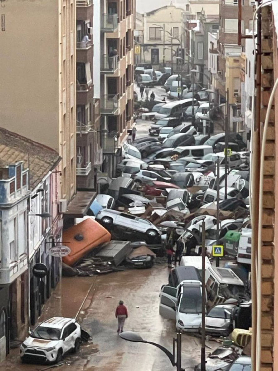
Valencia is the European version of the same event. On October 29, 2024, a year's worth of rain fell on eastern Spain in a single day and more than 230 people died.
The rain alone did not do it. Alerts reached people late; the split between regional and national authority slowed the response; and years of building on flood plain, served by an ageing drainage network, left the water nowhere to go. A city can survive the meteorology and still drown on the administration.
The ingredient Valencia needed - a sea warm enough to load the atmosphere above it - is this year present across the whole basin rather than in one corner of it.
The whole ocean is running hot
The Mediterranean is the warm corner of a warm planet rather than an outlier. July 2026 tied July 2024 as the hottest month in 176 years of record-keeping, at 1.18C above the twentieth-century average on the US National Oceanic and Atmospheric Administration's reckoning and 1.47C above pre-industrial on the Copernicus and World Meteorological Organisation numbers.
Sea surface temperatures set their own July record, running 1.02C above average - the first July past that mark - with the daily reading for the 60S-60N band closing the month at 21.05C. The Persian Gulf hit a record 36C while Iran sweltered near 50C.
Close to 40% of the world's ocean area was in a marine heatwave in June, with the hottest patches in the Mediterranean and the Pacific more than 10C above normal. The oceans absorb more than 90% of the excess heat trapped by burning fossil fuels, which is why their temperature is the cleanest single measure of how far the warming has run.
“Current conditions could indicate the beginning of a new phase, leading, once more, to uncharted territory,” said Carlo Buontempo, director of the Copernicus Climate Change Service.
The Pacific is louder
The biggest signal of the year is not in the Mediterranean at all. A super El Nino arrived early and is still strengthening. Temperatures in the benchmark Nino 3.4 region of the central Pacific are already 1.8C above average and closing on the 2C mark that defines a “super” event, and NOAA puts near-certain odds on it lasting into February 2027.
Nine of ten forecast models describe a strong-to-historic event. NOAA's Climate Prediction Center puts the chance of it reaching “very strong” by the November-January peak at around 63% - the top tier of a scale reached by only a handful of events since the 1950s.
El Nino is the warm phase of a natural Pacific cycle that recurs every two to seven years and normally emerges during the northern autumn. What makes this one different is the surface it is landing on: a record-warm global ocean, with the natural cycle stacked on top of the long-term trend rather than fluctuating around a stable baseline.
Its fingerprints show up in rainfall as much as in heat. El Nino years typically bring heavier rain to California and South America and drier conditions to Australia and Southeast Asia. Hurricanes near the United States tend to be suppressed, while cyclones elsewhere come in stronger and wetter.
The food bill
Capital Economics counts three channels of disruption from an extreme El Nino year: food price inflation, lost power generation where hydro reservoirs run dry, and logistics broken up by extreme weather.
“An El Nino in the second half of the year - as seems increasingly likely - would add to the upside pressures on food and energy prices,” wrote William Jackson, the firm's chief emerging markets economist. “The macroeconomic effects would be largest in emerging markets, particularly those most sensitive to higher food prices, including India and parts of Africa, as well as those where power generation might be curtailed such as Colombia.”
Food can account for 30% or more of the consumer price basket and over a quarter of GDP in parts of South Asia and Sub-Saharan Africa, which is where a bad harvest turns into a political problem fastest.
Soft commodities move first. Fitch Solutions expects Cote d'Ivoire's cocoa crop to come in at 1.7mn tonnes in the 2026/27 season, down 17.5% year on year, with Ghana flat at 670,000 tonnes. Smallholders dominate both, with little irrigation and no capacity to absorb an input shock.
Staples are better insulated. Wheat and corn are grown across enough geographies that a bad year in one is usually covered by another. The concentrated markets have no such cushion - cocoa, coffee, sugar and palm oil all moved sharply during the 2023-24 cycle - and neither does copper, if heavy rain interrupts mining in Chile and Peru.
Europe has spent this summer managing the drought: reservoirs down, reactors off, rivers too low to cool anything. The heat that caused it is still sitting in the sea. It has to come out somewhere, and the only thing not yet settled is which coastline is standing there when it does.
The IntelliNews PRO service includes access to reports, exclusive market data, and more news that decision-makers care about. Stay ahead of the market with IntelliNews PRO.
Sign Up Now


